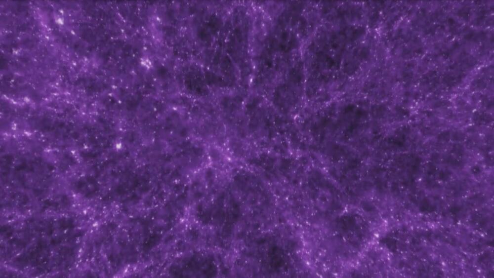
Menu

Blog

Archive for the ‘mapping’ category: Page 42

Jun 15, 2020

Terra® Robot Mower

Posted by in categories: mapping, robotics/AI

IRobot introduces® Robot Mower. With wireless boundaries and Imprint smart mapping,® knows your lawn like only you do.

Jun 11, 2020

The Batch: AI’s Progress Problem, Recognizing Masked Faces, Mapping Underwater Ecosystems, Augmenting Features

Posted by in categories: economics, mapping, robotics/AI

Last week, I wrote about the diversity problem in AI and why we need to fix it. I asked you to tell us about your experiences as a Black person in AI or share the names of Black colleagues you admire. Thank you to everyone who responded. It was heart-warming to hear from so many of you.

Many of you shared your frustration with the lack of mentors who understand your challenges, the alienation of being the only Black face at professional meetings, and the struggle to overcome economic and social inequalities. Black women, especially, wrote about the difficulties of building a career in AI. Some of you described your efforts to support Black people in science and technology and provide tech resources to underserved communities. Thank you for sharing with us your dreams and also your disappointments.

We will feature some of your stories in our Working AI blog series. Please stay tuned.

May 27, 2020

Inside the NSA’s Secret Tool for Mapping Your Social Network

Posted by in categories: mapping, mobile phones, privacy

Edward Snowden revealed the agency’s phone-record tracking program. But thanks to “precomputed contact chaining,” that database was much more powerful than anyone knew.

May 25, 2020

Galactic crash may have triggered solar system formation

Posted by in categories: mapping, space

The formation of the Sun, the Solar System and the subsequent emergence of life on Earth may be a consequence of a collision between our galaxy, the Milky Way, and a smaller galaxy called Sagittarius, discovered in the 1990s to be orbiting our galactic home.

Astronomers have known that Sagittarius repeatedly smashes through the Milky Way’s disc, as its orbit around the galaxy’s core tightens as a result of gravitational forces. Previous studies suggested that Sagittarius, a so called dwarf galaxy, had had a profound effect on how stars move in the Milky Way. Some even claim that the 10 000 times more massive Milky Way’s trademark spiral structure might be a result of the at least three known crashes with Sagittarius over the past six billion years.

Continue reading “Galactic crash may have triggered solar system formation” »

May 7, 2020

State-of-the-art lasers at the micro level

Posted by in categories: internet, mapping, robotics/AI

Many emerging technologies rely on high-quality lasers. Laser-based LiDAR sensors can provide highly accurate scans of three-dimensional spaces, and as such are crucial in applications ranging from autonomous vehicles to geological mapping technologies and emergency response systems. High-quality lasers are also a key part of the high-speed, high-volume data centers that are the backbone of the internet.

When assessing the quality of a , researchers look to the noise in a laser’s frequency, or the number of times the laser’s light wave toggles in each second. Low-quality, “noisy” lasers have more random variations in those toggles, making them useless for systems that are meant to return or convey densely packed information.

At present, lasers with adequately low frequency noise are bulky, expensive and an impractical choice for mass manufacturing. Penn Engineers have set out to solve this problem with a device called a “phase noise filter” that can turn low-cost, compact lasers into those suitable for LiDAR and more.

May 6, 2020

A new law for metamaterials

Posted by in categories: engineering, law, mapping, physics

Metamaterials, which are engineered to have properties not found in nature, have long been developed and studied because of their unique features and exciting applications. However, the physics behind their thermal emission properties have remained unclear to researchers—until now.

In a paper published in Physical Review Letters, Sheng Shen, an associate professor in Carnegie Mellon’s department of mechanical engineering, and his student Jiayu Li, a Ph.D. candidate, have created a new scale law to describe the thermal emission from metasurfaces and metamaterials.

“With this new scale law uncovering the underlying physics behind the collective thermal emission behavior of metamaterials, researchers could easily utilize existing design and optimization tools to achieve desired thermal emission properties from metamaterials, instead of blindly searching for the best solution through mapping the entire design space,” Li said.

Apr 22, 2020

Dengue case predictor mapping system wins the 2019 NASA global hackathon

Posted by in categories: astronomy, big data, computing, disruptive technology, environmental, events, hacking, information science, innovation, machine learning, mapping, open source, satellites, science, software, space
Upper row Associate American Corner librarian Donna Lyn G. Labangon, Space Apps global leader Dr. Paula S. Bontempi, former DICT Usec. Monchito B. Ibrahim, Animo Labs executive director Mr. Federico C. Gonzalez, DOST-PCIEERD deputy executive director Engr. Raul C. Sabularse, PLDT Enterprise Core Business Solutions vice president and head Joseph Ian G. Gendrano, lead organizer Michael Lance M. Domagas, and Animo Labs program manager Junnell E. Guia. Lower row Dominic Vincent D. Ligot, Frances Claire Tayco, Mark Toledo, and Jansen Dumaliang Lopez of Aedes project.

MANILA, Philippines — A dengue case forecasting system using space data made by Philippine developers won the 2019 National Aeronautics and Space Administration’s International Space Apps Challenge. Over 29,000 participating globally in 71 countries, this solution made it as one of the six winners in the best use of data, the solution that best makes space data accessible, or leverages it to a unique application.

Dengue fever is a viral, infectious tropical disease spread primarily by Aedes aegypti female mosquitoes. With 271,480 cases resulting in 1,107 deaths reported from January 1 to August 31, 2019 by the World Health Organization, Dominic Vincent D. Ligot, Mark Toledo, Frances Claire Tayco, and Jansen Dumaliang Lopez from CirroLytix developed a forecasting model of dengue cases using climate and digital data, and pinpointing possible hotspots from satellite data.

Sentinel-2 Copernicus and Landsat 8 satellite data used to reveal potential dengue hotspots.

Correlating information from Sentinel-2 Copernicus and Landsat 8 satellites, climate data from the Philippine Atmospheric, Geophysical and Astronomical Services Administration of the Department of Science and Technology (DOST-PAGASA) and trends from Google search engines, potential dengue hotspots will be shown in a web interface.

Using satellite spectral bands like green, red, and near-infrared (NIR), indices like Fraction of Absorbed Photosynthetically Active Radiation (FAPAR) and Normalized Difference Vegetation Index (NDVI) are calculated in identifying areas with green vegetation while Normalized Difference Water Index (NDWI) identifies areas with water. Combining these indices reveal potential areas of stagnant water capable of being breeding grounds for mosquitoes, extracted as coordinates through a free and open-source cross-platform desktop geographic information system QGIS.

Check out the website here: http://aedesproject.org/

Winners visit the Philippine Earth Data Resource and Observation (PEDRO) Center at the DOST-Advanced Science and Technology Institute in Diliman, Quezon City with Dr. Joel Joseph S. Marciano, Jr.

Apr 18, 2020

Google Engineers ‘Mutate’ AI to Make It Evolve Systems Faster Than We Can Code Them

Posted by in categories: mapping, robotics/AI

Much of the work undertaken by artificial intelligence involves a training process known as machine learning, where AI gets better at a task such as recognising a cat or mapping a route the more it does it. Now that same technique is being use to create new AI systems, without any human intervention.

For years, engineers at Google have been working on a freakishly smart machine learning system known as the AutoML system (or automatic machine learning system), which is already capable of creating AI that outperforms anything we’ve made.

Now, researchers have tweaked it to incorporate concepts of Darwinian evolution and shown it can build AI programs that continue to improve upon themselves faster than they would if humans were doing the coding.

Mar 15, 2020

Toyota’s self-driving car mapping system could be a game changer

Posted by in categories: mapping, robotics/AI, transportation

With commercial satellite technology, Toyota showed it can create HD maps more quickly and do it in a cost-effective manner.

Mar 3, 2020

EnVision and the Cosmic Vision decision

Posted by in categories: evolution, mapping, space

In 2016, the European Space Agency announced a call for medium-size missions within their Cosmic Vision Program. In layman’s terms, “medium-size” means moderate-cost (less than 550 million euros, or $610 million) and low-risk, and this is achieved by keeping payloads small and by using proven, heritage technology for both spacecraft and payload. Alongside these common-sense conditions is a third and less tangible quality, that the project be scientifically robust. But when comparing excellent cases from vastly different fields, the merits of one scientific mission over another can seem subjective. It’s not enough to lament the dearth of data in said field, or to establish how a project will discover this or that, or even to show exactly how said “groundbreaking technology” will work. ESA wants a mission that will stir up an unprecedented level of excitement, support, and interest within the scientific community. Here is how they attempt to measure a project’s relevance.

“Each member state has a representative in the Science Programme Committee, and it’s their duty to define the content of the program,” said Luigi Colangeli, head of ESA’s Science Coordination Office. “Study groups work with the various proposals to arrive at something that is compatible with the boundary conditions, in this case, of a M-5, or medium-class mission. Right now, we are studying the evolution of the three missions. And then next year we will put together a peer review panel, who will analyze the three candidates and recommend the best selection to our Director of Science.”

Since the call went out four years ago, ESA have been whittling down proposals, from 25 at the beginning to only three now: Envision, Theseus, or SPICA. In February the EnVision conference took place at the National Centre for Space Studies (CNES) in Paris. EnVision is a low-altitude polar orbiter that is meant to perform high-resolution radar mapping, surface composition, and atmospheric studies of Venus. The purpose of the meeting was to call the Venus community to attention, because the clock is ticking. Consortium members, ESA representatives, and interested scientists from all over the world were in attendance.

Page 42 of 50First3940414243444546Last